|
|
|
Vietnam Space Center shares satellite images of Mekong river flood monitoring
|
|
|
Satellite image data from the Vietnam Data Cube System will be exploited by the Mekong River Commission to monitor flood movements and water resources.
|
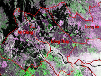
Monitoring floods in the Mekong Delta through satellite images. Photo: IE.
The Vietnam Space Center (VNSC) and the Mekong River Commission Secretariat signed a cooperation agreement on the exploitation of satellite image data for the management and development of water and related resources to Mekong River Basin.
Under the agreement, VNSC will create conditions for the Mekong River Commission to use and stabilize the use of Vietnam Data Cube's satellite image data sharing system, serving specific activities and projects in research and development of the Commission.
Data include satellite imagery, satellite imagery products, storage time, range of satellite imagery for monitoring and evaluation of water resources as well as related resources to the Mekong River Basin.
The Mekong River Commission is committed to ensuring the use of the Vietnam Data Cube System according to the goals and delivering effective results to its member countries.
The two sides will jointly use the Vietnam Data Cube satellite image sharing system to perform joint work or cooperate with a third party to research and support human resource training in accordance with the strategic plan of The Mekong River Commission and the Annual Work Plan are approved by the members of the Mekong River Commission. |
ntptuong
Follow www.nexpress.net |